Visibility Splays Explained: A Guide for Developers
If you're preparing a planning application that includes a new or altered vehicle access, you've probably come across the term visibility splay.
It's one of the most important highway design requirements, yet it's also one of the least understood by developers.
In simple terms, a visibility splay ensures that drivers leaving a site can see approaching traffic in sufficient time to enter the road safely. If adequate visibility cannot be achieved, the Local Highway Authority may object to a planning application on highway safety grounds.
This guide explains what visibility splays are, why they matter and how they are assessed.
What is a visibility splay?
A visibility splay is the area of land that must remain clear so that drivers and other road users can see each other.
Imagine sitting in a car at the site access. Before pulling out onto the road, you need to be able to see vehicles approaching from both directions. Equally, approaching drivers should be able to see you.
The visibility splay represents this unobstructed area.
Trees, hedges, walls, fences, parked vehicles and other objects can all reduce visibility and create potential safety issues.
How are visibility splays measured?
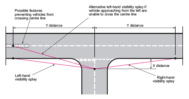
Visibility splays are normally expressed using two measurements.
For example:
2.4 metres x 43 metres
The first figure (2.4m) is known as the 'X distance'. It represents the distance that a driver's eye is set back from the edge of the carriageway whilst waiting to leave the site.
The second figure (43m) is known as the 'Y distance'. It represents the distance that must be visible along the road in each direction.
The required Y distance depends on factors such as vehicle speeds and the design guidance adopted by the Local Highway Authority.
Why are visibility splays important?
Good visibility helps drivers make safe decisions when entering or leaving a site.
Without adequate visibility, drivers may be forced to edge into the carriageway before they can see approaching vehicles, increasing the risk of collisions.
For this reason, highway authorities carefully assess visibility as part of the planning process.
What guidance is used?
Most highway authorities assess visibility using recognised design guidance.
Depending on the location and nature of the road, this may include:
Manual for Streets
Manual for Streets 2
Design Manual for Roads and Bridges (DMRB)
Local Highway Authority design guidance
The appropriate standard will depend on the characteristics of the road and the relevant local policies.
Conservative Visibility Requirements
The visibility required at a site access depends on several factors, including the characteristics of the road, the speed of approaching traffic and the highway design guidance adopted by the relevant Highway Authority.
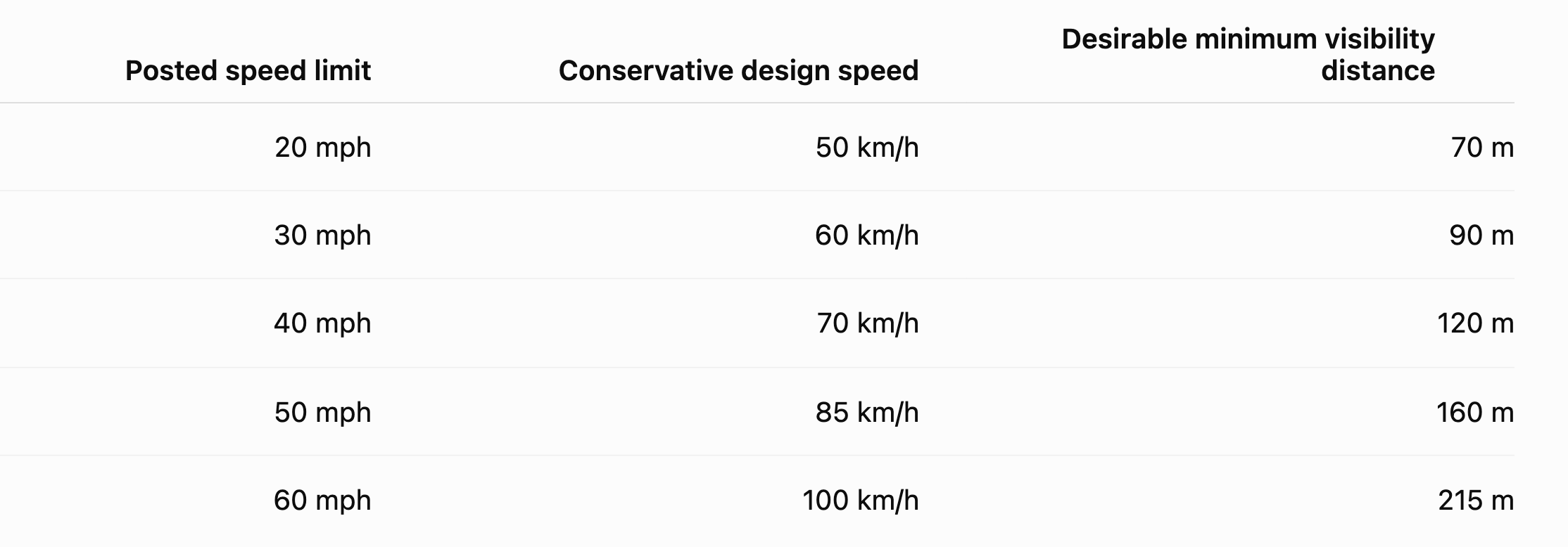
As a broad guide, the stopping sight distances commonly associated with the Design Manual for Roads and Bridges (DMRB) are shown below.
These distances should not be treated as fixed requirements for every site. The appropriate visibility splay will depend on the road type, the guidance adopted by the relevant Highway Authority, the observed speed of traffic and the particular circumstances of the access. On lower-speed streets, Manual for Streets or locally adopted standards may produce substantially shorter distances. A speed survey may also support a site-specific assessment where actual traffic speeds are lower than the posted speed limit.
What can affect visibility?
Several factors can restrict visibility from a proposed access, including:
Boundary walls.
Hedges and shrubs.
Trees.
Fences.
Buildings.
Changes in road alignment.
Parked vehicles.
Changes in ground level.
Sometimes only minor alterations are needed to achieve the required visibility, whilst in other cases more significant changes may be necessary.
Can visibility be improved?
Often, yes.
Potential solutions include:
Lowering or removing boundary walls.
Cutting back vegetation.
Relocating fences.
Repositioning the site access.
Setting gates further back from the highway.
Widening the access.
Every site is different, and the most appropriate solution depends on the specific constraints.
Does my land need to contain the entire visibility splay?
Not always.
Visibility splays often extend across land within the public highway.
However, where a splay extends over private land outside your ownership or control, the Local Highway Authority may require evidence that the visibility can be maintained for the lifetime of the development.
This is one reason why visibility should be considered at an early stage of the design process.
Can planning permission be refused because of visibility?
Yes.
Restricted visibility is one of the most common highway concerns raised during the planning process.
If drivers cannot obtain adequate visibility, the Highway Authority may conclude that the proposed access would create an unacceptable highway safety risk.
However, each proposal is assessed on its own merits, and in many cases relatively straightforward design changes can overcome these concerns.
Why early assessment is important
Visibility constraints are often identified during the planning application process, but they are much easier and less costly to resolve before a design has been finalised.
An early site assessment can identify potential issues, allowing access arrangements to be refined before an application is submitted.
This can reduce delays and improve the likelihood of obtaining planning permission.
How DW Transportation can help
DW Transportation provides visibility assessments for developments throughout South Wales and across the UK.
We assess proposed access arrangements, advise on the applicable design standards and work with developers, architects and planning consultants to identify practical solutions where visibility constraints exist.
Our aim is to resolve highway issues early and provide clear, evidence-based advice that supports successful planning applications.
Need advice?
If you're unsure whether your proposed access achieves the required visibility, we'd be happy to help.
Early advice can often identify simple design changes that avoid delays later in the planning process.
Contact DW Transportation today for an informal discussion about your project.
About the Author
Dean Watkins is Director of DW Transportation, an independent transport planning consultancy based in South Wales. With over 25 years' experience in transport planning, Dean advises developers, architects and planning consultants on Transport Statements, Transport Assessments, visibility assessments and highway design matters associated with planning applications across South Wales and the UK.